For More Inquiry
Karibu Aberdare National Park
Aberdare national park is located in central Kenya 164 km from Nairobi. The Aberdare national park is part of Aberdare mountain range. The national park was gazetted as a national park in 1950 mainly to offer refuge to wildlife and the Aberdare mountain range.
Aberdare national park sits between the elevation of 2000metres and 4000metres above the sea level and covers a total land area of 766 square kilometers which is comprised of moorland, bamboo forests, deep V-shaped valleys intersected by rivers, waterfalls, streams, rainforests among others.
The park was named after Aberdare mountain range which is an isolated volcanic range that forms the eastern arm of the rift valley that extends up to 100km north-south Nairobi.
Attractions in Aberdare National Park
Wildlife
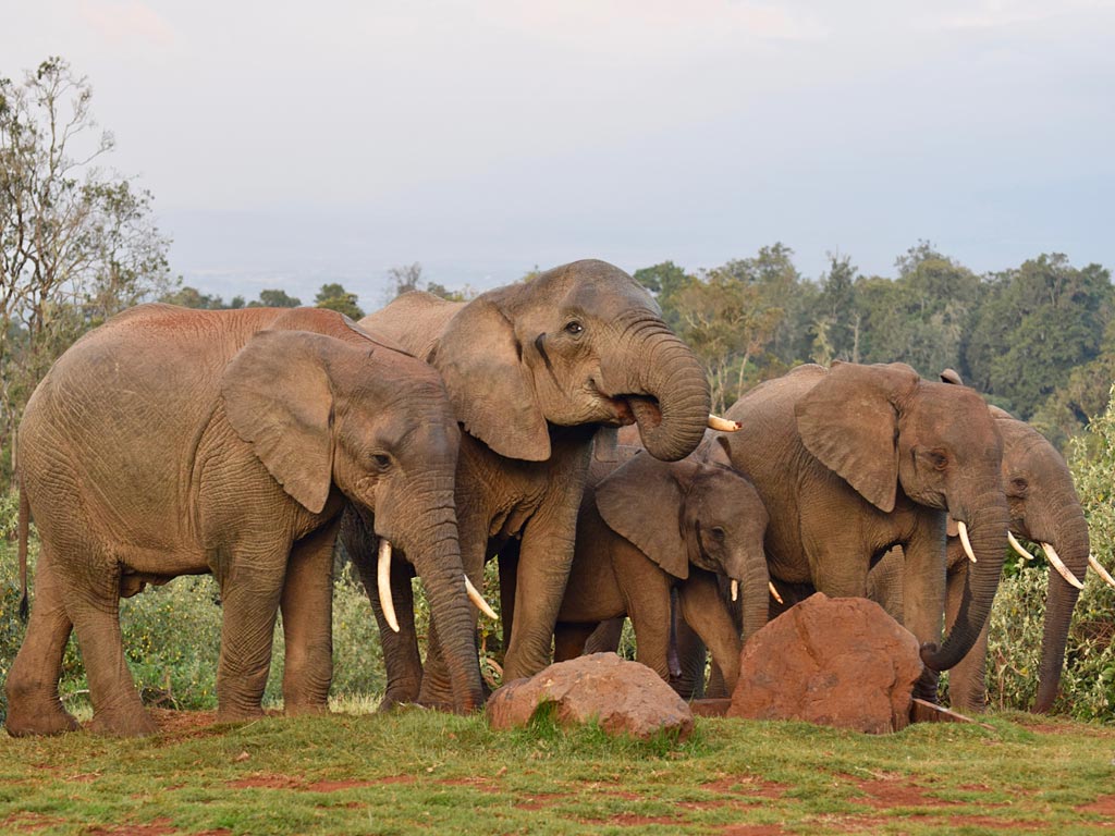
Aberdare national park is a great wildlife destination in Kenya with abundance of wildlife species including the Big Five (elephants, buffaloes, leopards, lions and rhinos) and the second largest population of endangered black rhinos in Kenya.
Other animals found in Aberdares national park include rhinos in Kenya, other animals found in the Aberdare national park include hyenas, bushbucks and defassa waterbucks.
You will also find reedbucks, olive baboons, black and white colobus monkeys, Sykes monkeys and many more.
In the higher moorlands of the Aberdare ranges there are common elands and serval, the salient area of the Aberdare national park is an elephant migration corridor with dense forests.
Here you will get bush pig, dik-dik, bushbuck, reedbuck and many more. nocturnal animals in Aberdares national park include giant forest hog and large spotted genet.
Birdlife
Aberdare national park is a birder’s paradise and one of the Important Birding Areas in Kenya, the park is a home to about 250 bird species recorded.
They include endemic species to the region that are the striking Hartlaub’s turaco, the indistinct Aberdare cisticola which are found at the higher altitudes of the park.
Other bird species found in Aberdares national park include scarlet-tufted malachite sunbird, Aberdare cisticola, Abyssinian crimsonwing, African goshawk and African green pigeon.
Others include African paradise flycatcher, African yellow warbler, Augur buzzard, Ayres’s hawk eagle, Bar-tailed trogon, Bronzy sunbird, Cinnamon-chested bee-eater, Crowned eagle, Doherty’s bush-shrike, Golden-winged sunbird and Hartlaub’s turaco.
Aberdares is also home to Hunter’s cisticola, Jackson’s francolin, Montagu’s harrier, Montane white-eye, Moorland chat, Moorland francolin, Mountain buzzard, Moustached green tinkerbird, Narina trogon and Olive ibis.
We also have Rufous-chested sparrowhawk, Scarlet-tufted malachite sunbird, Sharpe’s longclaw, Silvery-cheeked hornbill, Tacazze sunbird, Tambourine dove, White-headed wood-hoopoe and many more.
Aberdares Ranges
The Aberdare ranges are the signature feature in Aberdare national park, one of the best hiking sites in Kenya and from which the park gets its name.
The Aberdare ranges are 160 kilometers of an isolated volcanic range forming the eastern most of the Great Rift Valley.
The Aberdare ranges lie at the maximum elevation of about 4,000 meters above the sea level and its slopes are heavy forested, Aberdares ranges include
- Amount Santima – the highest peak
- Mount Kinangop – these second highest peak at 3,906 meters and situated on the southern end of the range
- Chebuswa at 3364 meters
- Table Mountain at 3791 meters
- Martini Hill at 3698 meters and
- Elephant at 3590 meters
On the west side of the Aberdare ranges, fall steeply into the Kinangop platea and on the East side they fall more gently from the peak. From the top of the ranges, you are able to see Lake Naivasha and Mau Escarpment.
The Aberdare ranges are heavily forested and dominated by various vegetation covers such as rainforests, dense bamboo forests and moorlands. The vegetation cover inhabits several animal species such as antelopes, monkeys and various bird species.
The Aberdare ranges are culturally significant to the local Kikuyu people, these people refer to the ranges as Nyandarua which means the drying hide due to the distinctive fold of its silhouette
The Aberdare ranges are significant to the local Kikuyu people who refer to the ranges as Nyandarua meaning drying hide due to the distinctive fold of its silhouette thus Tourist Attractions in Aberdares national park.
Aberdare ranges were given their name by the Aberdare by Joseph Thomson in honor of Lord Aberdare in 1884. Lord Aberdare was the president of the Royal Geographic Society and the Royal Historical Society.
Unique Mountain Vegetation
Aberdare national park’s landscape is dominated by unusual vegetation cover comprising of several vegetation types such as the steep forested ravines and open moorlands.
Aberdare national park comprises of 778 species of vegetation and plant species, the vegetation cover and its types are attributed to the park’s altitude and rainfall. Some of the tree species found in Aberdares national park include hardwood species such as camphor, cedar, podo and hagenia.
Unsual Vegetation
The park is also dominated by Afro-alpine moorlands dominating the Aberdares mountain range, this vegetation type is divided into a rich alpine and sub-alpine flora.
Here you will find species such as Senecio, Lobelia, Erica, Helichrysum and tussock grasses giving away to around 3,000 meters to the bamboo Arundinaria alpine and the montane rainforests
Montane rainforests in Aberdares national park consists of species such as Juniperus procerus – podocarpus falcatus – Nuxia congesta forest on the western and the northwestern slopes are dominated by Ocotea forest.
On the south – East and moxed podocarpus litifolius forest on the east and on Kipiriri. In the rolling moorland there occurs pockets of the Hagenia forest in the sheltered patches thus Tourist Attractions in Aberdares national park.
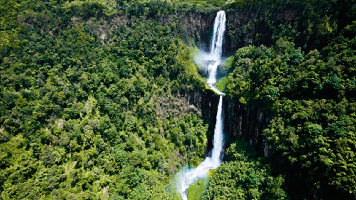
Waterfalls
Aberdare national park comprises of magnificent waterfalls plunging from cloud-shrouded heights and spray in to the beautiful ravines.
Among the numerous waterfalls there is the beautiful Karuru waterfalls which is the main waterfall in the park. Karuru waterfalls features 3 steps flowing at different levels, these include
- 1st step at 117 meters
- 2nd step at 26 meters and
- 3rd step at 130 meters
Other impressive waterfalls in Aberdares national park include
- Gura falls on the opposite side of Karuru falls
- Magura falls cascading across the mouth of Queen’s cave
Waterfalls in Aberdares national park are reached on a walk of about 8 kilometers via the Mutubio West Gate, the hike is about 20 minutes through the forests.
Cultural and Historical Sites
Aberdare national park is filled with several great cultural and historical sites making the park a perfect destination to visit for cultural and historical safaris, cultural and historical sites to enjoy in Aberdares national park include
-
The hideout of Mau leader Dedan Kimathi
The hideout of Mau leader Dedan Kimathi is a significant historical site in the history and independence struggles of Kenya, the site was used as a hideout Dedan Kimathi a leader of Mau-Mau rebellion during the Kenya independence struggles.
The hideout of Mau leader Dedan Kimathi is situated between Homi campsite and Elephant Ridge and Aberdare ranges. During their stay, Dedan Kimathi and his companions learned to use ropes of jungle welfare fighting in Burma in the Second World War.
-
Mugumo (fig) tree
The Mugumo (fig) tree in Aberdares national park is a huge tree of cultural significance, this tree is situated down on the slopes of the Aberdare ranges.
This very old tree possess a rich history usually narrated by the locals living in the communities situated adjacent to the park thus Tourist Attractions in Aberdares national park.
During the Mau-Mau rebellion, the tree was used for communication purposes, the Kenyan Mau-Mau fighters who freed used to curve crevices in truck of the tree and they used it as an undisclosed post office where they put messages through agents.
In memory of Dedan Kimathi, this tree was named Kimathi Post Office after him. Aberdares national park is known for its old caves which were used as hideouts for the Mau-Mau fighters during the Guerilla revolution against the British colonists.
-
The Kikuyu local community
The Kikuyu local people were the early inhabitants of area presently known as the Aberdares national park, when the area was gazetted as a national park, they were evicted to the areas across the boundaries of the park.
The kikuyu believe that the Aberdare ranges are one of the homes of their god Ngai, this area was initially named and called Nyandarua “meaning drying hide” by the locals. And this is due to the numerous distinctive folds in the area.
Top things to do in Aberdare national park
Mountain climbing
Hiking is an exciting and adventurous activity in Aberdare park. There are various mountain peaks in the park which offer hiking safaris for example elephant hill hike which stands at 3720 meters above the sea level and is a 26 km hike.
During the elephant hill hike you will be able to view various animals, Sasamua dam, Ndakaini dam. You can also hike Ol Doinyo Satima Mountain which stands at an elevation of 4000 meters above the sea level.
Mount Satima which is also known as the mountain of the young bull was named after an explorer joseph Thompson and it’s the highest peak in the Aberdare range. Hiking to Satima peak gives you magnificent views of the rift valley, Mount Kenya, wildlife species among others.
Due to its elevation hiking Satima peak needs one to have warm clothes because it gets cold as you hike to the summit which takes about 5 hours round hike trip.
There are other mountains like Kinangop which is located in the south and Kipipiri Mountain which is located in the west of the mountainous moorlands.
Game drives in Aberdare national park
This is one of the exciting and most done activities in the park. game drives in Aberdare park can either be done on a half day or full day following trails like the salient zone where you will have clear views of animal species.
They include wildlife such as black rhinos, elephants, buffaloes, spotted hyenas, leopards, black and white colobus monkeys, bushbucks, elands, bongo antelopes, giant forest hogs among others.
During the game drive you will also be able to view waterfalls like Karuru which flows into three steps, Magura falls, Chania falls and have spectacular views of scenery, vegetation, mountain streams, hills among others.
Trout fishing
Aberdare park is one of the best destinations for trout fishing in that there are three rivers which offer easy access to fishing including Chania, Gura and Ambone rivers.
Trout fishing in the park is done by the help of an experienced guide who will show you how to fish and areas where to fish from. During trout fishing you are required to have fishing gears and a fishing license which can be obtained at the park headquarters.
Bird watching
Aberdare national park is among the listed birding destinations in Kenya in that it harbors over 290 bird species including endemic species which are only found in Kenya and near endemic species which are also found in the neighboring countries.
On your Kenya birding safari in the park, you should look out for bird species like African paradise flycatcher, Aberdare cisticola, African green pigeon, Jackson’s francolin, hunters cisticola, golden winged sunbird, crowned eagle, mountain buzzard, white headed wood hoopoe, silvery cheeked hornbill, Sharpe long claw, rufous chested sparrowhawk, olive ibis, narina trogon, tambourine dove, emerald green malachite sunbird, double collared sunbird among others. Birding in Aberdare national park can either be done during the guided nature walk or the game drive.
Where to stay in Aberdare national park
There are a wide range of accommodations where you can stay on your safari in Aberdare national park. The lodges in the park range from luxury, midrange, budget and they include the Ark, Aberdare Country Club, Treetops Lodge, Aberdare Cottages and Fishing Lodge, Tusk Camp Banda, Campsites, Sapper hut among others.

Best time to visit Aberdare national park
Aberdare national park can be visited anytime throughout the year though the best time is during the dry season in the months of June to September and December to February.
During this time there is less rainfall in the park therefore access roads to Aberdare national park will be passable, hiking trails in the park will be dry and passable compared to the rainy season when the trails are muddy and slippery. During the dry season there will be short grass in the park which enables you to clearly view the wild animals.
How to get to Aberdare national park
Aberdare national park is located in central Kenya, north of Nairobi and can be accessed by both road and air transport means
When using road transport the national park is located 160km from Nairobi which takes about 2 to 3 hours’ drive therefore you will fly to Jomo Kenyatta international airport in Nairobi.
Connect by road where by you will drive on a tarmac road and the park has various gates like Shamata or rhino gate which can be accessed when you are coming from Nyahururu and Mutubio gate which can be accessed when coming from Naivasha.
When using air transport you will book scheduled or chartered flights from Wilson airport which is located in the southern part of Nairobi to Mweiga or Nanyuki airstrips and then connect to the park headquarters by road.
There are several domestic airlines which operate flights to the park for example Airkenya, Safarilink among others. Booking of domestic flights to Aberdare national park can be done through a tour operator.


Land of the Tswana
There are so many places that you can visit in Botswana but there are some other attractions that stand out more than others and are worth visiting during Botswana Safari. These make the list of the top Tourist Attractions In Botswana.
There are many tours that you can do in Botswana and the most common is the overland tour, where you can drive around to most parts of the country in an overland truck. Most common tours include a Botswana Wildlife Safari, Victoria Falls and Chobe National Park package, Desert tracking, Premium safaris and 5 to 10 day safaris.
-
- Exploring ancient ruins, historical landmar.
-
- Immersive cultural experiences, local.
-
- Hiking, trekking, extreme sports, and out.
-
- A romantic destination like Paris, Venice.
-
- Kid-friendly activities, theme parks family.
-
- Premium accommodations, gourmet.


Destination
Aberdare National Park

Recommended Package

Starting From:
TAXES INCL/PERS

Starting From:
TAXES INCL/PERS

10 Days
Starting From:
TAXES INCL/PERS
Join The Newsletter
To receive our best monthly deals

